Search and rescue drones are useful because they give incident commanders a fast, low-risk way to see what is happening before people walk into the unknown. In the UK, that matters on cliffs, hills, flood edges, collapsed structures, and long coastal searches where time, visibility, and access all work against the team on the ground. This article breaks down how they are used, what sensors actually matter, where they fit best, and the rules that shape real operations in 2026.
What matters most before a drone is sent into a search
- Thermal imaging helps most when the scene is cold, exposed, or visually cluttered, but it still needs a trained observer to separate signal from noise.
- For UK rescue work, the aircraft is only half the system; comms, deconfliction, and data handling decide whether it adds value.
- Multirotors suit close-in searches, fixed-wing platforms suit wide-area sweeps, and hybrid VTOL systems sit between the two.
- The CAA’s rules still matter during an incident, especially around emergency helicopters, privacy, and Remote ID.
- The strongest programmes build SOPs, battery logistics, and training before they buy expensive sensors.
How a drone changes the first hour of a search
I think the best way to understand drone support in rescue is as a triage tool, not a magic answer. It helps turn a broad, uncertain search into a smaller, more deliberate one by showing the team where heat, movement, tracks, wreckage, or access problems actually are. That is a big shift in the first hour, because the first hour is usually where bad assumptions do the most damage.
In practice, the workflow is simple when it is done well:
- Define the search area from the last known position, weather, terrain, tide, and witness reports.
- Fly a structured pattern instead of drifting around and hoping to spot something.
- Use live video and thermal data to mark clues, not just to watch the scene.
- Hand verified coordinates to ground teams so they can move with purpose.
The drone is most valuable when it narrows uncertainty. A good search pilot is not trying to “find everything”; the real job is to remove the dead space in the map and give the rest of the team a credible lead. That only works, though, if the aircraft is equipped for the task, which is where sensor choice matters.
What makes a rescue drone worth deploying
I would not buy for thermal alone. Thermal imaging is the headline feature, but a rescue drone earns its place through the whole package: sensor quality, flight stability, link reliability, and how quickly the crew can turn what they see into a decision. A weak airframe with a great camera is still a weak rescue asset.
| Feature | Why it matters | Where teams often get it wrong |
|---|---|---|
| Thermal imaging | Helps detect people, recent movement, or heat contrast in darkness, heather, water margins, or broken terrain. | Assuming thermal gives a clean answer in every scene; rocks, livestock, machinery, and sun-warmed surfaces can all mislead. |
| Optical zoom | Lets the operator confirm a target without flying dangerously close. | Buying a camera with zoom but not enough gimbal stability to use it properly in wind. |
| Live video link | Shares the scene with command staff in real time so they can task ground teams faster. | Ignoring latency, weak reception, or poor recording workflows until the first major incident. |
| Hover control | Makes cliff-edge checks, roof inspections, and small-area confirmation much easier. | Using a platform that is too twitchy to hold position when the wind picks up. |
| Battery workflow | Keeps searches moving instead of stopping every short sortie. | Buying spare batteries without charging, storage, and rotation plans. |
| Position accuracy | Helps turn a visual clue into a usable coordinate for responders on the ground. | Leaving geotagging and map handoff as an afterthought. |
| Spotlight or speaker | Can help with contact, marking, or reassurance in the final phase of a find. | Assuming every mission benefits from extra payload weight and shorter endurance. |
| Weather tolerance | Matters in spray, drizzle, or grit, which is a realistic UK constraint. | Reading the spec sheet as if the drone will perform the same way in real wind and rain. |
The pattern is consistent: the best kit is the one that helps a team make a better decision, faster, with fewer people exposed to risk. Once the payload is right, the next question is where the drone will actually earn its keep.
Where they help most in the UK
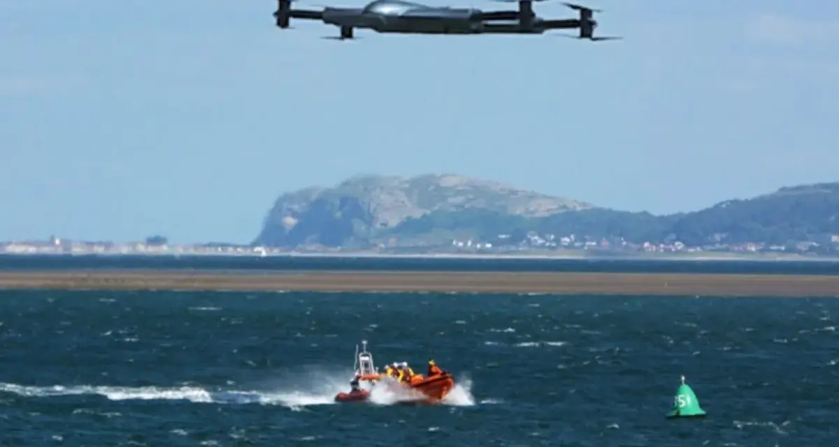
In the UK, I see the strongest fit in exposed terrain and hard-to-reach spaces: coastal cliffs, moorland, mountains, flooded ground, bridges, roofs, and industrial edges. Mountain Rescue England and Wales reported roughly sixty operational drone deployments across England and Wales in 2024, and that kind of use makes sense to me because the search problem there is usually “find the person or the hazard quickly,” not “replace the team on the hill.”
| Environment | Why drones help | Main limitation |
|---|---|---|
| Coastal cliffs and beaches | They can sweep long shorelines quickly, check ledges, and support tide-sensitive searches without putting crews at the edge. | Wind, salt spray, and glare can make flight and detection harder than the map suggests. |
| Mountains and moorland | They cover large, broken terrain faster than ground teams and can spot a person or heat source that would otherwise blend into the landscape. | Terrain folds, shadows, and signal drop-outs can create blind spots. |
| Floodplains and riverbanks | They reduce the need for wading or boat movement when rescuers only need a first look. | Rain, reflections, and fast-changing conditions can reduce thermal clarity. |
| Urban roofs and bridges | They help check places that are unsafe or slow to reach on foot. | Clutter, multipath signal, and privacy concerns are more visible here. |
| Collapsed or damaged structures | They offer a safe reconnaissance layer before anyone enters a hazardous area. | Dust, confined spaces, and interference can make the flight itself difficult. |
I would be cautious, though, about assuming every dramatic terrain is automatically a drone win. Dense canopy, warm rocks, livestock, wet bracken, and busy urban backgrounds can all create false positives, which is why a good operator treats the feed as evidence to interpret, not proof to trust blindly. That operational fit still sits inside a legal framework, and in the UK the rules are not a footnote.
How UK rules shape rescue missions
The UK rulebook is practical, not decorative. The CAA Drone Code is clear that operators must not hamper emergency services at an incident, and if a helicopter or rescue aircraft is already working the scene, the safe move is to clear the airspace and let it pass. For public safety teams, that is not theory; it is part of the job.
Three points matter most to rescue work:
- Emergency coordination - If an incident is active, flights need to be deconflicted, and a drone should stop unless the emergency services give permission to continue.
- Remote ID - In 2026, this is a live procurement and compliance issue. Some UK classes need it from 1 January 2026, and by 1 January 2028 it becomes universal unless an exemption applies.
- Beyond visual line of sight - BVLOS operations are not something to improvise. If a team wants to fly BVLOS in an atypical air environment, it needs the right CAA Operational Authorisation.
I also think privacy deserves more attention than it often gets. Rescue footage can include casualties, bystanders, and private property, so the live feed and any recordings should be treated as sensitive operational data, not casual video. Once the rules are clear, the platform choice becomes much simpler.
Choosing the right airframe for the mission
When teams ask me what to buy, I usually start with the terrain and the search pattern, not the brand. A multirotor, a fixed-wing aircraft, and a hybrid VTOL machine all solve different problems, and the wrong choice can waste time even if the hardware itself is excellent.
| Platform | Best for | Typical endurance | Strength | Trade-off |
|---|---|---|---|---|
| Multirotor | Close-in searches, hovering over a clue, roof checks, cliff edges, and confined spaces | About 20 to 40 minutes | Precise positioning and quick deployment | Shorter range and more sensitivity to wind |
| Fixed-wing | Large rural sweeps, mapping, and long corridors | About 45 to 120 minutes | Covers a lot of ground per sortie | Cannot hover, and launch/recovery is less flexible |
| Hybrid VTOL | Mixed terrain, remote launch points, and searches that need both range and hover | About 30 to 90 minutes | Runway-free operation with better reach than a basic multirotor | More complex, usually heavier, and often more expensive |
My default choice depends on the mission, not the spec sheet. For a casualty confirmation in rough terrain, I would lean toward a multirotor every time. For a wide moorland or shoreline sweep, fixed-wing or hybrid starts to make more sense. The important thing is to match the tool to the search geometry, not to the most impressive brochure. But hardware alone never delivers a rescue outcome.
What makes the programme succeed after the drone is bought
The part most teams underinvest in is the boring middle: who flies, who observes, who talks to command, who logs the clues, and who keeps the batteries healthy. That is where a lot of promising drone programmes drift into underuse. The airframe gets attention, then the workflow quietly fails.
- Training - The observer needs to read thermal contrast and terrain cues, not just stare at the screen.
- SOPs - Search patterns, lost-link procedures, and helicopter deconfliction should be written before the incident, not improvised during it.
- Data security - Live feeds and recordings should have access control, retention rules, and a clear handoff process.
- Maintenance - Batteries, propellers, firmware, and sensor calibration matter more than most marketing copy admits.
- Deployment discipline - Fly with a defined task. Random hovering burns battery and attention without improving the search.
I also see a security angle here that is easy to miss. A rescue drone is not just a camera in the sky; it is a data source inside a live emergency. If the team cannot secure the feed, protect privacy, and preserve useful evidence, it is leaving value on the table. That is why the strongest units look a bit unglamorous from the outside: they rehearse, log, deconflict, and keep the kit simple enough to trust under pressure.
What I would prioritise for UK rescue use in 2026
If I were building a new rescue-drone capability in 2026, I would start with the mission profile, the people, and the airspace, then choose the aircraft. The right platform is the one that can repeatedly produce usable information in your actual terrain, weather, and response window, not the one that looks best in a demo.
That is why the best programmes are rarely the flashiest ones. They pair a stable airframe with a clear search doctrine, secure comms, trained observers, and clean coordination with other responders. When all of that is in place, a drone becomes more than a gadget with propellers; it becomes a practical force multiplier that can shorten searches, reduce risk, and improve the odds of a good outcome.