A VTOL drone solves a straightforward problem: it lifts off vertically, then keeps the efficiency of forward flight once it is airborne. That makes it useful wherever space is tight, routes are long, or setup time matters more than the romance of runway-style launch. In the UK, the category matters even more in 2026 because class marks, Remote ID, and operating rules now shape what you can actually do with the aircraft.
The short version is that vertical lift buys access, range, and flexibility
- Hybrid vertical-lift aircraft are strongest when you need both a compact launch area and efficient forward flight.
- They are often a better fit for mapping, corridor inspection, and security or infrastructure work than a pure multirotor.
- Multirotors still win for close-up inspection, simple filming, and short jobs in cramped spaces.
- In the UK, the right class mark, Flyer ID, Operator ID, and Remote ID setup can matter before you even think about payload.
- Do not compare aircraft on hover time alone; mission efficiency, wind tolerance, software, and support often matter more.
What makes vertical lift different in practice
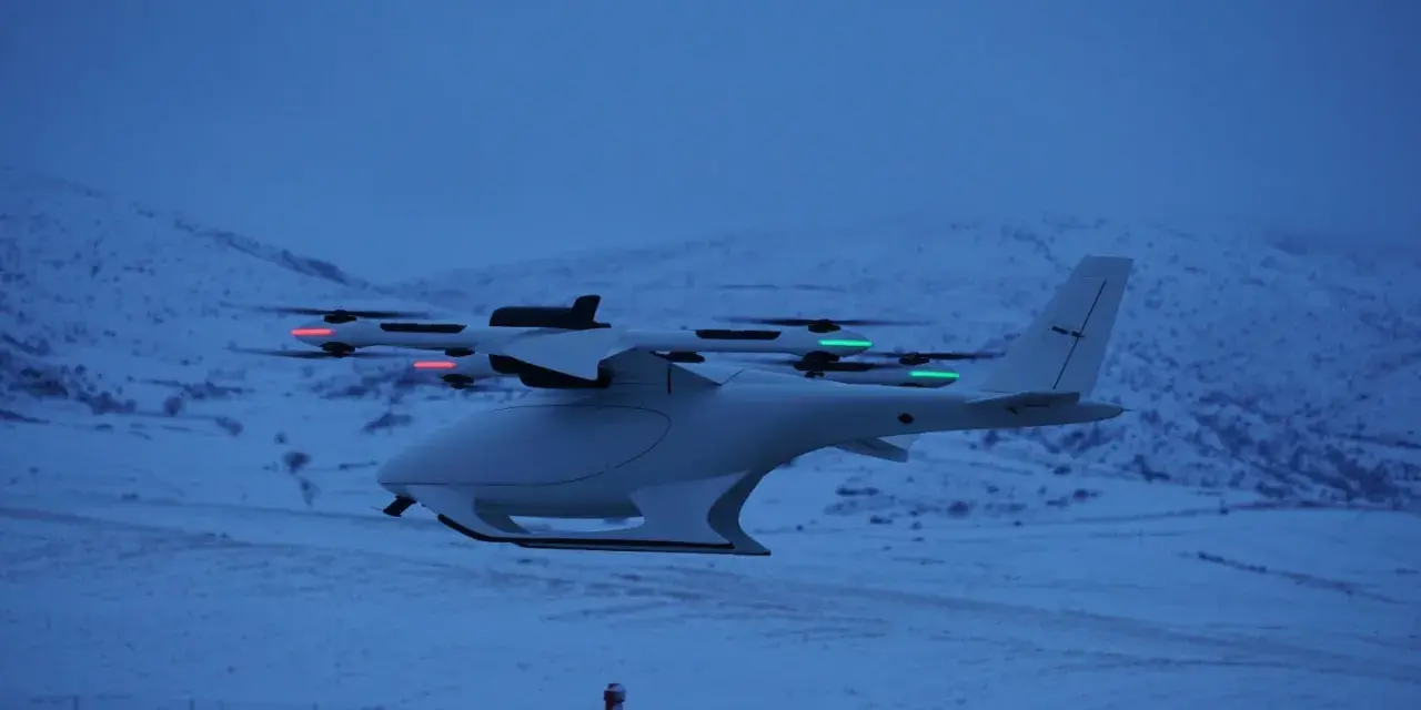
The real value of this kind of aircraft is not just that it can take off without a runway. It is that it can combine two behaviours that usually pull in opposite directions: vertical take-off and landing, and efficient forward flight. A multirotor is brilliant at hovering and tight manoeuvres, but it burns energy quickly. A fixed-wing aircraft covers ground efficiently, but it needs a launch and recovery plan. A hybrid machine sits in the middle.
I think of it as a workflow tool first and an aircraft second. If I am trying to inspect a roof, scan a solar farm edge, or map a long road corridor, I care less about the novelty of the airframe and more about whether it gets me in, out, and home with useful data. That is where a vertical-lift design earns its keep. The payload, which is simply the camera or sensor it carries, becomes part of the mission rather than an afterthought.
There is also a practical transition benefit that buyers often underestimate. Once the aircraft is airborne, it can move like a fixed-wing platform and spend less time fighting gravity. That usually means better endurance, better coverage, and less battery waste for area work. The next question is where that advantage is most visible on the ground.
Where it earns its keep in the real world
For me, the strongest use cases all share one thing: the job is bigger than a simple hover, but the site is too awkward for a conventional runway-based aircraft. Mapping is the obvious example. On a survey site, a vertical-lift platform can launch from a car park, a verge, or a small cleared patch and still cover a large area efficiently once it transitions into forward flight. Some survey-grade systems now advertise roughly an hour of tested flight time, but the real number always drops once you add wind, payload, altitude, and reserve battery.
That same logic applies to corridor work. Roads, rail, pipelines, power lines, flood defences, and long utility assets benefit from a craft that can launch from one safe point, work along a line, and land without requiring a strip of open terrain. In security and critical-infrastructure settings, that flexibility matters too. A team can stage from a secure location, get airborne fast, and inspect a perimeter or asset without building a whole launch operation around the flight.
Emergency response is another strong fit. When access is poor or the terrain is cluttered, vertical take-off saves time. Search teams, incident assessors, and site managers do not always have the luxury of a long setup. The aircraft that gets the first useful image is often the one that matters.
- Area mapping works well when you need broad coverage from a tight launch site.
- Line inspection works well when the mission follows roads, rails, wires, or pipelines.
- Security and infrastructure checks benefit from rapid deployment and a compact footprint.
- Emergency response benefits from launch flexibility and reduced ground logistics.
That sounds persuasive, but not every mission justifies the added complexity. The next step is comparing the three main aircraft types honestly, not romantically.
Hybrid, multirotor, or fixed-wing
This is the comparison I would make before spending money. It is easy to be impressed by flight footage and forget the boring details that decide whether the aircraft fits the job. A good comparison should cover take-off style, endurance, payload behaviour, and the actual cost of ownership, not just the headline spec.
| Platform | Take-off and landing | Typical endurance | Best for | Main trade-off | Rough budget |
|---|---|---|---|---|---|
| Multirotor | Vertical in a very small footprint | 20 to 35 minutes | Close inspection, filming, confined sites | Shorter flight time and limited coverage | About £400 to £3,000 |
| Fixed-wing | Needs runway, catapult, or belly landing | 60 to 120 minutes | Large-area mapping and long corridors | More launch and recovery logistics | About £2,000 to £15,000 |
| Hybrid VTOL | Vertical lift with forward-flight efficiency | 40 to 70 minutes | Surveying, inspection, mixed sites, security work | More complex mechanics and higher support needs | About £5,000 to £30,000+ |
If I need to get close to a façade, a roof edge, or an awkward piece of plant, I still reach for a multirotor first. If I need to cover a county-scale map or a very long route, fixed-wing still has a place. But when the site is awkward and the mission still demands efficient coverage, the hybrid machine is usually the most balanced option. That balance only works if you choose the aircraft for the mission, which is where most buyers go wrong.
How I would choose one without overbuying
I usually start with mission shape rather than airframe shape. I ask whether the job is a point mission, a line mission, or an area mission. Point missions are things like detailed inspections of a single asset. Line missions follow infrastructure. Area missions are about mapping and repeatable survey work. Once that is clear, the spec sheet becomes easier to read.
Start with payload and data quality
If the camera, thermal sensor, LiDAR, or multispectral package is the reason you are buying the platform, then the payload should drive the decision. A heavier payload often reduces endurance, changes handling, and increases the importance of balance and weather. RTK, which gives centimetre-level positioning through satellite corrections, is useful for survey work, but it is not a substitute for good flight planning or calibration.Then check the control link and software
I care a lot about the radio link, mission-planning software, and export workflow. A reliable aircraft that cannot move cleanly into GIS, CAD, or evidence-management systems creates friction every week. For security-sensitive work, I would also look at firmware updates, data handling, and whether the platform supports secure connections and clear audit trails. Connectivity is not a side topic; it is part of the product.
Read Also: Hawaii Drone Laws - Fly Legally & Avoid Fines
Finally look at support, spares, and repairability
Battery count, spare propellers, arm replacement, and local service support affect real uptime more than a glossy brochure does. A platform that needs to be shipped across the country for a simple repair is a hidden cost. The same is true of training. If the aircraft requires specialist pilot habits, bake that into the budget from day one.
- Check whether the payload you need is natively supported, not just “possible” through an adapter.
- Check the real mission duration, not the headline endurance under perfect conditions.
- Check whether the software exports cleanly into the tools your team already uses.
- Check how quickly batteries, arms, and sensors can be replaced.
- Check whether the data path is acceptable for a sensitive site or regulated customer.
Once I know the aircraft fits the job, I move on to the part many people leave too late: compliance in the UK. That is where a good purchase can still become a poor operator experience if the paperwork and operating category do not line up.
The UK rules that matter before you buy or fly
The UK Civil Aviation Authority tightened the framework again in 2026, and that matters even if you only want a practical tool rather than a regulatory project. Any new model placed on the market from 1 January 2026 must have a UK class mark. If you are buying older stock, you may be dealing with legacy rules or European class marks instead, so the label on the aircraft matters more than the marketing name.
For most buyers, the registration basics are simple but non-negotiable. According to the CAA, you need a Flyer ID if the aircraft weighs 100g or more, and you need an Operator ID if you own or are responsible for an aircraft that weighs 250g or more, or 100g or more with a camera. From 1 January 2026, Remote ID also became part of the picture for UK1, UK2, and UK3 class aircraft, which means the aircraft transmits identity and location data in flight.
| Rule | Practical impact |
|---|---|
| Fly below 120m | Keep the aircraft below 120m, or 400ft, above the earth’s surface. |
| Keep clear of uninvolved people | Distance rules depend on class and category, but vertical-lift does not cancel them. |
| Use the right ID | Flyer ID and Operator ID are now part of normal UK operation for most aircraft. |
| Match the class mark | New 2026 models should show a UK class mark; older models may still be treated as legacy aircraft. |
| Think about insurance | If you fly for work, third-party liability insurance is required. |
There is one more practical point I would not skip: bigger or more advanced aircraft can move you out of the simple Open category. If you want to operate beyond the standard limits, the CAA framework can require authorisation. That is why the right purchase is not just about the machine. It is about the operating path attached to it.
The limits and mistakes that catch people out
The biggest mistake I see is treating vertical lift as if it removes operational friction. It does not. It removes one kind of friction and introduces others. A hybrid aircraft still needs careful preflight checks, good weather judgement, and room for a safe transition. If the wind is poor, the battery reserve is thin, or the payload is too heavy, the advantage shrinks fast.
Range and endurance also get overstated. Marketing copy tends to talk about best-case flight time, but real missions include climb, transition, turnarounds, gusts, and reserves. If the site is high, the air is thin; if the payload is heavy, endurance drops; if the route is long and the operator wants a conservative reserve, the available mission time falls again. I would rather buy a platform with honest margins than one with an impressive number that only works in a lab.
There is also a data-quality trap. People assume the aircraft type solves the survey problem on its own. It does not. Poor flight planning, shaky camera settings, weak ground control, or a bad correction workflow will still produce messy output. The same goes for connectivity. If the link is unstable, or if the platform cannot handle the site’s security requirements, the aircraft becomes harder to trust in professional work.
- Do not buy on flight time alone.
- Do not ignore payload weight when comparing platforms.
- Do not assume vertical take-off means unrestricted operation.
- Do not forget battery, spares, and repair turnaround.
- Do not treat data handling as an afterthought on sensitive sites.
Once those limits are clear, the buying decision gets much simpler. The best platforms are not the ones with the flashiest demo video. They are the ones that stay useful once the weather changes, the job gets messy, and the data has to move into a real workflow.
What I would prioritise in 2026 if I were buying one
If I were choosing a vertical-lift platform this year, I would rank priorities in this order: mission fit, compliance path, data workflow, and support. That sequence matters because it stops you from paying for performance you cannot legally or operationally use. It also keeps the purchase grounded in the real work, not in spec-sheet theatre.
- Mission fit: area survey, corridor inspection, or close-up asset work.
- Compliance path: class mark, registration, Remote ID, and the right operating category.
- Data workflow: how quickly the imagery or sensor output gets into the tools you use.
- Security and connectivity: stable links, sensible firmware updates, and clear data handling.
- Maintainability: batteries, spares, repair turnaround, and local support.
The broader future-of-flight story is interesting, but the immediate value is simpler: a better launch footprint, cleaner coverage, and less wasted setup time. That is why a good vertical-lift drone feels less like a gimmick and more like a serious tool. If I were buying for mapping, infrastructure, or security work in the UK, I would choose the platform that makes the mission easier every single week, not the one that merely looks clever on paper.