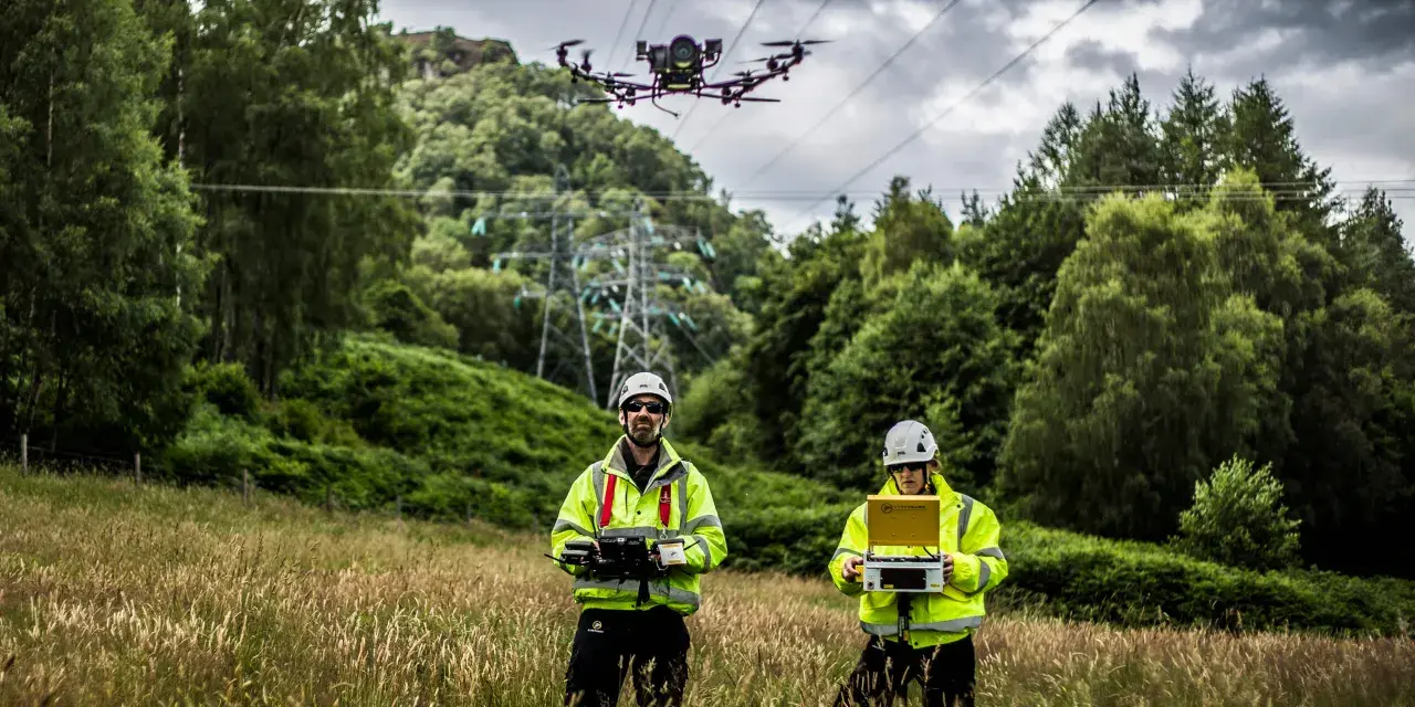
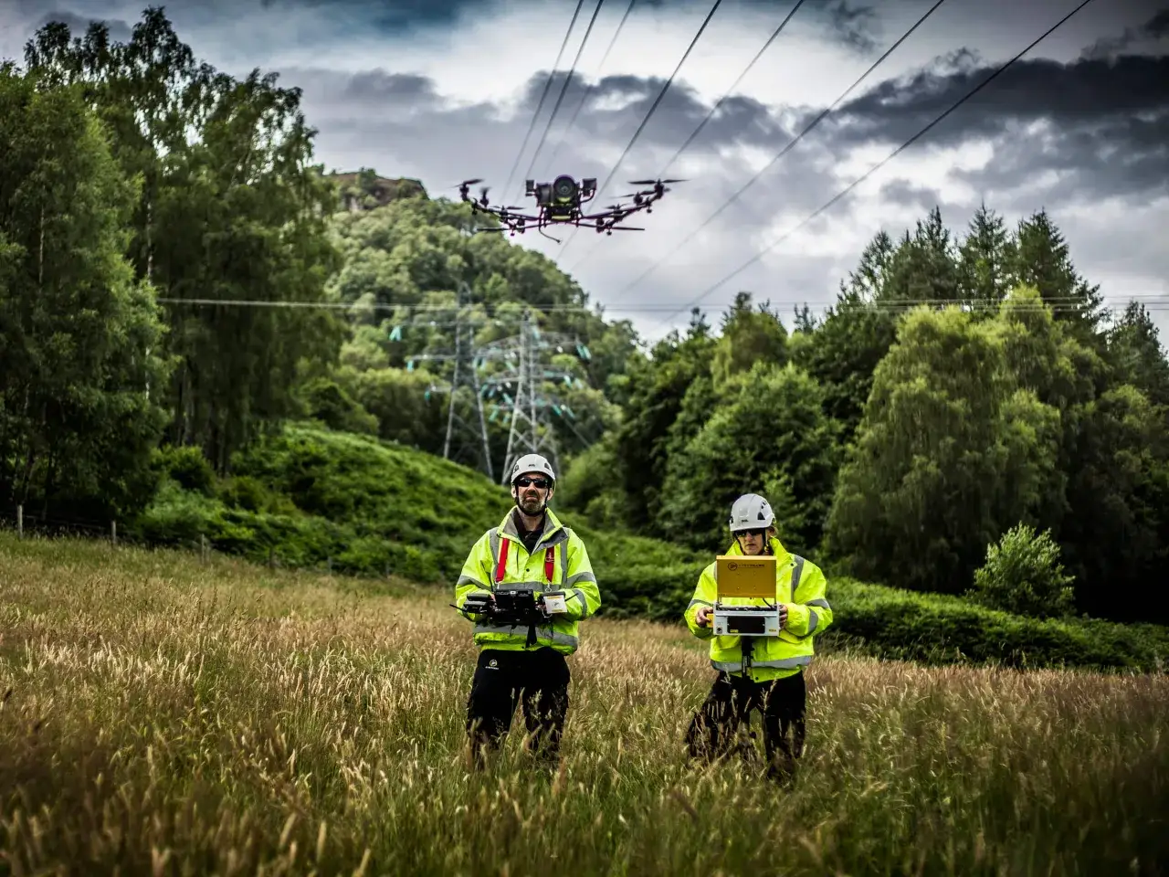
Drone inspection of overhead lines has moved from niche trial to practical infrastructure work. The real value is not the flight itself; it is the ability to spot defects earlier, keep people away from live assets, and turn visual evidence into maintenance decisions that are easier to defend. In the UK, the regulatory layer matters just as much as the camera stack, so the right approach is part technology, part operations.
The main value is early fault detection, safer access, and faster maintenance decisions
- Most utility work is about inspection first: towers, insulators, clamps, conductors, vegetation, and right-of-way condition.
- For close-proximity or beyond-visual-line-of-sight missions, the UK usually pushes operators into the Specific Category with CAA authorisation.
- The most useful payloads are usually RGB zoom, thermal, and LiDAR, because they reveal different classes of defects.
- Drones rarely replace line crews; they reduce wasted visits and help crews arrive with a better plan.
- Commercial operations in the UK also need the usual basics: registration, correct IDs, insurance, and privacy discipline.
What a drone actually does on overhead lines
On a power corridor, a drone is most useful when it behaves like a close-up inspection tool, not a flying novelty. It can move along the span, stop at problem points, and capture the kind of evidence a ground team often cannot see clearly from below: cracked insulator shells, heat-stressed connectors, loose fittings, corrosion, damaged dampers, or vegetation creeping into the clearance envelope.
For maintenance planning, that matters more than it sounds. A good survey does not just say, “something looks wrong.” It tells you what is wrong, where it is, and how urgent it is. That changes whether a crew needs to be dispatched this week, bundled into a larger job, or monitored on the next pass.
I draw a hard line between inspection and repair support. Drones are excellent at finding and documenting issues; they are much less about physically fixing them. In practice, they support maintenance by reducing uncertainty, prioritising work, and giving engineers a cleaner picture of asset condition before anyone climbs a tower or shuts down a circuit. That distinction becomes important when comparing drones with older inspection methods.
Once that role is clear, the next question is why drones have become such a strong fit for this work in the first place.
Why drones beat traditional patrols in most utility use cases
The old alternatives still have a place, but they each come with a weakness that matters on long line routes. Helicopters are fast over large distances, yet expensive and less granular. Ground patrols are straightforward, but slow and often blocked by terrain, access rights, or visibility. Climbing crews give the best hands-on detail, but they are not the right tool for routine scouting.
| Method | Best for | Strength | Limitation |
|---|---|---|---|
| Drone | Routine line patrols, defect verification, vegetation checks, storm triage | Close-up imagery, repeatable routes, lower exposure for staff | Weather limits, battery limits, regulation limits, data review overhead |
| Helicopter | Very long corridors and rapid regional surveys | Coverage speed and reach | Higher cost, noise, less precise close-range evidence |
| Ground patrol | Accessible sections with clear sightlines | Simple logistics and low equipment overhead | Slow, visually limited, dependent on terrain and access |
| Climb or outage crew | Actual repair work and hands-on verification | Direct physical access to the asset | Highest exposure, most labour, often overkill for simple diagnosis |
The biggest operational win is not just cost, although that helps. It is the shift from occasional, labour-heavy inspection to repeatable condition monitoring. That makes the grid easier to manage after storms, easier to prioritise during vegetation growth, and easier to audit when asset owners need evidence. The market direction is clear enough that major network operators are already moving this way; National Grid has publicly described centralised autonomous inspections close to live infrastructure as part of its operating model.
That said, the real value only appears when the mission is flown and processed properly, which is where the workflow matters more than the hardware brochure.
How a real inspection mission is run
A useful drone programme is built like an engineering process, not an ad hoc flight. The best teams I see keep the mission simple, repeatable, and tied to the maintenance system from the start.
- Define the asset and the question. Are you checking for conductor damage, insulator wear, vegetation encroachment, storm impact, or a suspected hotspot?
- Set the operating profile. Decide whether the job can stay within standard visual flying or needs BVLOS, closer proximity, or a more controlled site setup.
- Choose the right capture method. Visual imagery is fine for many jobs, but thermal or LiDAR may be needed if the question is electrical loading or clearance.
- Capture with enough overlap and context. A single good photo is rarely enough; repeat angles, geotags, and asset references are what make the record useful later.
- Review and classify findings quickly. Good operators tag defects by type and severity instead of dumping a folder of images on the client.
- Push the result into maintenance planning. The output should become a work order, a revisit, or a documented no-action decision.
For long corridors, BVLOS is the real unlock. It lets a team inspect infrastructure beyond the immediate reach of the pilot, and that is why the UK regulator has been working to make those operations easier for infrastructure use cases. In practice, this is the difference between a drone being a clever tool and a drone becoming part of the network’s operating rhythm.
Once the workflow is settled, sensor choice becomes the next decision that separates decent data from genuinely useful data.
Which sensors matter most
For power-line work, the best payload is the one that answers the question with the fewest blind spots. I would not buy around a brand first; I would buy around the defect types you need to catch.
| Sensor or output | What it finds | Best use case | Where it falls short |
|---|---|---|---|
| High-resolution RGB camera | Broken hardware, corrosion, missing components, surface damage, bird activity | General inspection and documentation | Cannot see heat loss or hidden structural clearance issues by itself |
| Zoom optics | Fine detail on insulators, clamps, spacers, and fittings | Close-range defect confirmation without physical approach | Needs stable flight and good piloting discipline |
| Thermal imaging | Hotspots, overloaded connections, poor joints, abnormal heating | Electrical condition checks and prioritisation | Temperature alone does not tell the whole story; context matters |
| LiDAR | Clearance, sag, vegetation proximity, 3D corridor geometry | Right-of-way analysis and planning around encroachment risk | More complex processing and usually higher programme cost |
| AI-assisted review | Pattern detection, defect triage, trend spotting | Large asset portfolios where manual review would be too slow | Should support, not replace, human sign-off |
My practical bias is simple: if the job is routine inspection, RGB plus zoom is the baseline; if the grid question is electrical health, add thermal; if the question is clearance or vegetation, LiDAR earns its place quickly. The strongest programmes usually combine at least two sensing modes, because a single sensor tends to create comfortable but incomplete certainty. That is why regulation and operating discipline matter next.
The UK rules that shape utility operations
In the UK, line-inspection work is usually not a casual Open Category exercise. The moment you move into more complex operations, close proximity, or BVLOS, you are in territory where the Civil Aviation Authority expects an operational authorisation and a stronger safety case. In other words, the aircraft is only half the story; the operating model is the other half.| UK requirement | Why it matters for line work |
|---|---|
| Flyer ID for drones of 100g and above | Needed for most practical inspection aircraft, not just hobby toys |
| Operator ID for drones of 100g and above with a camera | Most inspection drones carry cameras, so registration is usually unavoidable |
| 120m / 400ft max height | The common legal ceiling in standard flying; important when planning terrain and span profiles |
| 50m distance from people in the standard rules | Useful to remember near roads, footpaths, and work sites with passing traffic |
| 150m from residential, recreational, commercial, and industrial areas in the A3 setup | Limits where simple Open Category flying makes sense |
| Commercial insurance | Required if the flight is work-related |
| Permission to take off and land | Landowner access still matters, even if the line itself is the target |
| Privacy discipline | Corridor work often passes near homes, gardens, roads, and private land |
Once the compliance layer is understood, the bigger operational mistake becomes easier to spot: people overtrust the drone and underappreciate its limits.
Where drones struggle and how to avoid bad data
Drone programmes fail less often because of the aircraft itself and more often because of poor mission design. The most common problems are weather, bad capture discipline, and sloppy interpretation.
- Wind and turbulence can make close inspection near spans, towers, and sharp terrain changes less reliable.
- Rain, icing, and low cloud reduce both safety margin and image quality.
- Glare, shadow, and contrast issues can hide small defects or make them look worse than they are.
- Dense steelwork and cluttered corridors make flight planning harder and increase the need for a cautious approach.
- Data overload can bury the real problem if the team does not use a clear defect taxonomy.
- AI false positives can waste crew time if model output is accepted without human review.
Here is the rule I would keep: a pretty flight is not the same thing as a useful inspection. Good data comes from consistent capture angles, repeatable routes, explicit asset tagging, and a review process that separates “interesting” from “actionable.” If you are building a programme, insist on a defect classification scheme from day one. Otherwise, the team ends up with lots of images and very little decision support.
That leads to the final question: what actually makes a programme worth scaling instead of leaving it as a pilot project?
What separates a useful programme from a flashy demo
The difference is usually boring, which is a good sign. The best utility drone programmes are the ones that integrate into the organisation’s normal maintenance rhythm instead of sitting outside it.
Start with one corridor type and one clear business question, such as vegetation clearance, post-storm damage, or hot-spot screening. Then measure the things that matter: time to report, repeat-visit rate, defect confirmation rate, and how often crews reach a site with a better plan because of the drone data. If those numbers improve, the programme has a real role.
I would also look for three structural habits: data integration with GIS or asset management systems, sensible escalation rules for urgent defects, and documented operating limits for weather, access, and privacy. If a provider cannot explain those three cleanly, the platform is probably more impressive in a demo than in day-to-day grid work.
For UK operators, the winning setup in 2026 is usually a mix of compliance discipline, close-up sensing, and a workflow that turns inspection findings into maintenance action quickly. That is where the technology stops being a gadget and starts behaving like infrastructure intelligence.