Flying drones in state parks is rarely a simple yes-or-no decision. In the UK, the practical equivalent is usually a mix of national parks, country parks, council-run green spaces, and other publicly managed natural areas, each with its own rules on top of the Civil Aviation Authority’s baseline. This article breaks down what actually matters before takeoff: legal requirements, land manager permissions, wildlife and privacy concerns, and the practical checklist I would use before I ever arm the motors.
The safest approach is to treat park drone flying as a permission and compliance exercise first
- The UK Civil Aviation Authority sets the flight rules, but the land manager can still ban takeoff, landing, or flying altogether.
- Most camera drones need a Flyer ID and an Operator ID before outdoor use in the UK.
- The common default limits are 120m maximum height, visual line of sight, no flying over crowds, and no dropping items.
- In parks, wildlife disturbance and visitor privacy are often the real reasons a flight gets refused.
- Light drones are easier to justify in open parkland, but they do not remove the need for permission.
What the UK rules actually mean in parkland
The current UK drone code is the floor, not the ceiling. According to the UK Civil Aviation Authority, most people flying outdoors need to think about two registrations first: a Flyer ID if the drone weighs 100g or more, and an Operator ID if the drone weighs 100g or more and has a camera. In practice, that means most consumer camera drones are not something you can casually unpack and launch without paperwork.
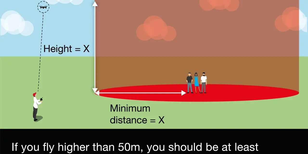
The usual Open category baseline is straightforward: keep below 120m (400ft), maintain visual line of sight, do not fly over crowds, do not carry dangerous goods, and do not drop articles. Those rules matter even more in parks because the environment changes quickly. A quiet field can become a busy dog-walking route in ten minutes, and a scenic viewpoint can turn into a crowd magnet without warning.
There are also class-based exceptions that matter for lighter aircraft. Drones below 250g, or UK0, UK1, C0, and in some cases C1-class drones, have more flexible rules around uninvolved people than older hobby drones. As of 2026, the CAA also allows a temporary C1 proximity relaxation from 1 January 2026 through 31 December 2027. That helps, but it does not make a busy park a free-for-all. A park manager can still say no, and a crowded trail remains a bad place to test the limits.
| Rule layer | What it controls | Why it matters in parkland |
|---|---|---|
| CAA drone code | Height, line of sight, distance from people, IDs, airspace | Sets the legal baseline for the flight itself |
| Land manager or byelaws | Takeoff, landing, access, opening hours, no-drone zones | Can stop the flight even when aviation rules would allow it |
| Privacy and conservation concerns | Filming people, nuisance, wildlife disturbance | Often the reason a technically legal flight still gets challenged |
That split between aviation law and land control is where most mistakes begin, so the next question is who actually owns the ground beneath your feet.
Who controls the land matters as much as the aviation rules
In the UK, the entity that manages the park can be a local council, a national park authority, a charitable estate, Forestry England, or a private landowner. That matters because the drone rules do not give you automatic access to land. If you are standing on a car park, verge, picnic field, or viewpoint that you do not own, you may still need permission to be there in the first place, and you may also need permission to use that spot as your launch or recovery point.
I treat this as a simple test: if I cannot identify the land manager, I am not ready to fly. Many public places have explicit no-drone policies, and some will only allow drone use for commissioned work, surveys, or tightly controlled filming. The National Trust, for example, does not permit unauthorised drone flying over its land. That is not a universal park rule, but it is a good reminder that beautiful public landscapes are often managed conservatively.
Some local authorities also treat drone use as part of filming policy and may ask for permission, proof of insurance, or a fee. The key point is that the aviation law may say the air is open, while the land manager says the site is closed. Both can be true at the same time.
- Ask who manages the land, not just who owns the road to it.
- Confirm whether takeoff and landing are allowed, because that is usually the real permission gate.
- Check for byelaws, filming policies, seasonal restrictions, and quiet zones.
- Get written permission when the flight is for work, repeat content, or anything public-facing.
Once the land manager is clear, the next limiter is the park itself: wildlife, visitor pressure, and the noise footprint of the aircraft.
Wildlife, visitors, and noise are the real constraints
A park is not empty space. It is usually a layered environment with walkers, cyclists, dogs, nesting birds, livestock, and people who came for quiet rather than aerial footage. A drone can be fully legal under the CAA code and still be a poor choice if it disturbs wildlife or makes a public path feel intrusive. That is especially true in spring and early summer, when breeding birds and other sensitive species are more vulnerable.
Noise is underrated. A small drone may look harmless on paper, but in a valley, near water, or over hard reflective surfaces, the sound carries farther than most pilots expect. Hovering makes this worse because the machine becomes a persistent presence rather than a quick pass. If I can hear a drone clearly from the ground, I assume other people can too, and I reassess whether the shot is worth the friction.
Privacy matters just as much. People in parks often expect a bit of openness, not aerial filming from above their heads. Even when you are not recording faces intentionally, a camera drone can capture identifiable details if you loiter over paths, benches, picnic areas, or secluded spots. I would never treat “it is legal” as the end of the discussion. If people are visibly uneasy, that is a signal to move on.
A useful rule of thumb is this: if your flight depends on people not noticing, or on birds staying put, the plan is probably too fragile for a public natural area.
With those realities in mind, the next decision is whether your drone setup is sensible for the location or simply too much aircraft for the job.
Which drone setups are most realistic in parks
Not every drone is equally suited to public green space. Some are easier to justify because they are light, quiet, and less risky around people. Others demand more separation, more paperwork, and a higher tolerance for operational friction.
| Drone setup | Best use in parks | Main trade-off | My view |
|---|---|---|---|
| Sub-250g / C0 / UK0 / UK1 | Establishing shots, hiking content, quick documentation | More sensitive to wind and less capable than heavier platforms | The easiest category to justify in open, low-density areas |
| Mid-weight consumer drone | Higher-quality scenic footage and more stable framing | More distance management and a greater chance of upsetting visitors | Only sensible when the park is genuinely quiet and open |
| Commercial or Specific-category operation | Paid filming, surveys, repeat work, controlled capture | More authorisation, planning, and risk management | Worth it only when the output is important enough to justify the overhead |
If you fly a C1-class drone, remember the temporary 2026 to 2027 flexibility around uninvolved people, but do not confuse that with permission to fly anywhere. The moment a site is busy, sensitive, or tightly managed, the practical advantage shrinks quickly.
For recreational flying, insurance is optional under UK rules, but for commercial work, third-party insurance is required. That is one of those details people ignore until something goes wrong, and by then it is too late to care about the fine print.
The right drone can make park flying easier, but only a disciplined pre-flight routine turns that advantage into something dependable.
A pre-flight routine I would actually use
Before I launch in any park or protected landscape, I work through the same sequence. It takes a few minutes, but it prevents most of the predictable problems.
- Identify the land manager and confirm whether drone use is allowed, restricted, or limited to specific purposes.
- Check the airspace for airports, heliports, temporary restrictions, and any local exclusion zones.
- Confirm my IDs and make sure my drone category matches the flight I want to do.
- Scan for wildlife and people at the exact time of day I plan to fly, not just on a map.
- Pick a launch site that is away from paths, car parks, livestock, and likely gathering points.
- Set a hard altitude limit, return-to-home behaviour, and an abort point before takeoff.
- Plan the exit so I can land fast if conditions change or people move into the area.
I also keep the flight simple. Parks are not the place for experimental maneuvers, long-range composition games, or risky low passes. If I cannot keep the aircraft in clear view, or if the shot depends on hovering near people, I treat that as a failed plan rather than a challenge to solve in the air. If the checklist still points to risk, the better move is to skip the flight and choose a different capture method.
When not to fly and what to do instead
There are times when the right answer is simply no. If the park has a clear no-drone policy, if visitors are dense, if the habitat is sensitive, or if the flight would be awkward to explain to a ranger, I would not push for a workaround. In practice, the best drone decision is often the one that protects your future access as much as your current footage.
That does not mean you are out of options. A long lens from a public viewpoint can deliver the same visual story with less friction. A scheduled, off-hours permit may be available for commissioned work. If the scene matters more than the flight itself, you can also move outside the boundary, use ground-level footage, or combine drone shots with maps and archival visuals. Those alternatives are sometimes more honest anyway, because they do not pretend that public nature is a blank canvas.
For me, the core rule is simple: aviation rules tell you what is allowed in the air, but the park manager, the wildlife, and the people on the ground decide whether the flight makes sense. When those three line up, park drone work can be clean, legal, and useful; when they do not, the smartest pilot is the one who puts the drone back in the case.