Iceland is one of those places where drone flying looks straightforward until the local geography, conservation rules, and airport restrictions start doing the real work. The practical truth is that iceland drone laws combine a European-style operating framework with site-specific bans, permits, and temporary no-fly zones, so the safest approach is to separate the general aviation rules from the location rules. In this guide I cover the limits that matter most, the places that catch visitors out, and the steps I would follow before taking off.
The rules that matter before you launch
- Most hobby flights fall under the open category: under 25 kg, visual line of sight, under 120 m, no crowds, no dropped items.
- The drone usually needs an operator registration number on it, and pilot competence matters once you go beyond the lightest toys.
- Night flying is allowed if you keep VLOS and use the required green flashing light.
- Airports, sensitive sites, and protected areas can override the general rules with local restrictions or permits.
- If the flight is commercial, beyond visual line of sight, or otherwise higher risk, expect authorisation rather than a simple takeoff.
How Iceland's drone framework is structured
I think of Iceland as a layered rulebook. The base layer is the standard European drone framework, with open, specific, and certified categories; the second layer is Iceland's own geo-zones and area-specific restrictions. That means the drone's weight is only part of the equation. Where you fly matters just as much as what you fly.
For most visitors, the open category is the starting point because it covers low-risk flights. The specific category is for operations that need more control or an explicit authorisation, and the certified category is reserved for the most demanding use cases. If your plan is simple sightseeing footage, you usually live in the open category until a site rule, an airport zone, or a commercial requirement pushes you upward.The useful mindset is simple: national aviation rules tell you how to fly, while the location rules tell you whether you are allowed to launch there at all. That distinction becomes important as soon as you leave a car park and point the drone at a waterfall, a national park, or an urban landmark.
The open-category rules that cover most everyday flights
The official open-category rules are not difficult, but they are strict in the places that matter. If I were flying casually in Iceland, I would treat the following as non-negotiable:
| Rule | What it means in practice |
|---|---|
| Weight | The drone must be under 25 kg. |
| Visibility | Keep the drone in visual line of sight at all times. |
| Altitude | Stay below 120 m from the ground. |
| People | Do not fly over crowds of people. |
| Cargo | Do not carry dangerous goods or drop objects. |
| Identification | Mark the drone with the operator's registration number. |
| Night use | Allowed if VLOS is maintained, but the drone needs a green flashing light at night. |
There is one useful altitude nuance that many people miss: the Icelandic rules allow flight above 120 m only when you are within 15 m of an artificial object and have the owner's approval. That is a narrow exception, not a creative loophole. I would only use it if I had a clear reason and written permission.
The open category is also split into A1, A2, and A3. A1 is the lightest-touch option for C0 and C1 drones, including some legacy drones under 250 g. A2 is the closer-to-people subcategory for C2 drones and requires extra competence; the official page notes 30 m without low-speed mode and 5 m with low-speed mode. A3 is the more distant, low-density option for larger drones, with a 150 m buffer from residential, commercial, industrial, or recreational areas.| Subcategory | Typical drone | Best fit | Distance rule to keep in mind |
|---|---|---|---|
| A1 | C0 and C1, plus some legacy drones under 250 g | Light recreational use | No flight over assemblies of people |
| A2 | C2 | Closer work around people | 30 m without low-speed mode, 5 m with low-speed mode |
| A3 | Up to 25 kg | Open terrain away from people | 150 m from residential, commercial, industrial, or recreational areas |
That is the part of the rulebook that most directly affects day-to-day flying. Once those basics are clear, the real question is where Iceland's geography or conservation rules tighten the screws.
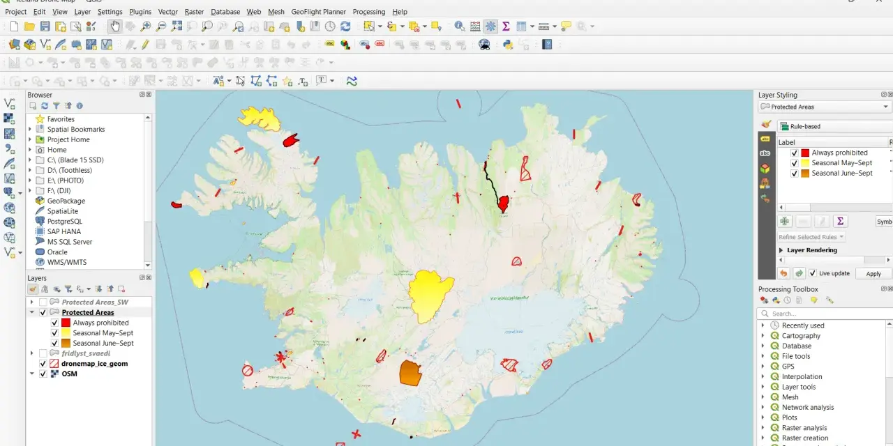
Where you can fly and where the map takes priority
Iceland is not a place where I would rely on a scenic assumption. Airports, protected landscapes, and security-sensitive sites can all override a perfectly legal-looking flight plan. The island's drone map and geo-zones matter because they separate the "technically possible" from the "actually allowed" areas.
| Zone type | Rule | Practical takeaway |
|---|---|---|
| Airports and airport zones | Flying without permission from the airport operator is prohibited on airport premises and within restricted zones around scheduled airports. | Do not improvise near aviation infrastructure; check the zone first. |
| Sensitive sites | No flight within 150 m of locations such as power plants, substations, Parliament, the Presidential residence, ministries, embassies, police stations, prisons, and hospitals unless authorised. | Assume a hard buffer unless you have explicit permission. |
| Protected areas and national parks | Local rules may ban flights outright, limit them by season, or require permission. | Read the site's own drone page before you travel. |
| Temporary restrictions | Security events, public gatherings, and emergencies can trigger short-notice bans. | Check same-day notices, not just the generic map. |
The local site rules are where people get caught out most often. Dynjandi, for example, bans drones from 1 May to 15 September unless permission has been granted. Vatnajökull National Park is more nuanced: recreational use is allowed in general, but there are area-specific prohibitions and time windows, and commercial projects need a proper permit rather than a casual assumption that "park rules" are enough.
That is why I would never plan an Iceland flight on the basis of scenery alone. The cliffs, waterfalls, and glacier lagoons are often exactly where the restrictions are strongest, and in conservation areas the Environment Agency of Iceland can be the real decision-maker.
From here, the next layer is the paperwork: who needs to register, who needs to pass an exam, and what the current fees look like.
Registration, age limits, exams, and fees
For the open category, operator registration is part of the game, not an optional extra. If you are already registered in another EASA member state, you should not register again in Iceland. If you are not in that system, I would check the Icelandic visitor-registration route before travelling, because the rules are designed around operator identity rather than around a single drone.
The age rule is equally straightforward: the minimum age for drone pilots is 16. Children under 16 can still use very light C0 drones under specific conditions, including guardian registration for the child's drone and supervision when required. That is a narrow family-friendly exception, not a general relaxation.
| Item | Current tariff | Notes |
|---|---|---|
| Individual operator registration | 5,863 ISK | Valid for 5 years |
| Legal entity registration | 7,462 ISK | Valid for 5 years |
| A1/A3 exam | 0 ISK | Online course and test |
| A2 exam | 7,462 ISK | Online course plus in-person test |
| Operational authorisation for higher-risk work | 18,358 ISK per hour | SORA/PDRA process, plus annual oversight fees |
The fees are not the hard part. The hard part is usually understanding whether your flight falls into the open category, needs extra competence, or has slipped into specific-category territory. If your drone is heavier, your location is sensitive, or the mission is commercial, the paperwork starts to matter quickly.
Commercial work, permits, and the specific category
Commercial flying is where many visitors overestimate their flexibility. A paid shoot is not automatically illegal, but it often triggers either a different category or a location-based permit. If the flight stays within the open category, the national rules may be enough. Once you move into more demanding operations, the specific category becomes the right framework, and that usually means authorisation or a formal declaration path. In practice, the specific category is the bucket for higher-risk operations such as beyond visual line of sight flights, heavier or more complex missions, and work that cannot safely fit the open-category limits. That is the point at which I would stop thinking like a holiday pilot and start thinking like an operator: mission planning, risk assessment, and paperwork all become part of the flight itself.Protected areas add another layer. Site managers may allow recreational use in some places but require explicit permission for commercial filming, research, or advertising. That difference matters, because a permit for a tourist flight and a permit for a production crew are not the same thing. Once you are asking permission to operate for a client, local authorities want to know about timing, footprint, and disturbance, not just the drone model.
For anyone building content or doing inspection work, I would separate the process into three checks: aviation compliance, land-access permission, and privacy/data review. The last one is easy to ignore, but Icelandic rules still expect you to respect personal privacy and property rights when people are nearby.
Once those permits are sorted, the final step is not legal theory. It is a pre-flight routine that keeps you from making a very expensive assumption on the day.
A pre-flight routine that avoids most problems
If I were flying in Iceland tomorrow, I would run the same checklist every time. It is simple, but it removes most of the bad surprises:
- Check the drone map on the same day you fly, not the week before.
- Confirm there is no airport zone, sensitive site, or temporary ban at the takeoff point, not just at the final subject.
- Verify the drone's weight, category, and operator registration number before packing.
- Plan the flight so you can keep visual line of sight without guessing where the drone is.
- Stay realistic about wildlife, visitor traffic, and wind; a legal flight can still be a poor flight if conditions are wrong.
- If the project is commercial or the location is protected, secure permission before you arrive on site.
The most common mistake I see is people treating empty ground as permission. In Iceland that is a weak read of the situation. A waterfall basin, a coastal viewpoint, or a glacier access road can be both visually open and legally constrained. The other common mistake is forgetting that rules can change quickly when public safety is involved, especially near airports, events, or active volcanic areas.
What matters once the drone is actually in the air
When you strip away the paperwork, the real operating discipline is pretty consistent: keep the drone in sight, keep it below the altitude limit, and keep it away from people, aircraft, and sensitive sites. The rest is location management. If a place has a site-specific rule, that rule wins. If a temporary restriction is published, that rule wins too. And if your flight has drifted from sightseeing into commercial or higher-risk work, the simpler open-category logic no longer applies.
That is the cleanest way to read the rules in practice, and it is the approach I would use on a real trip. If you remember only one thing from iceland drone laws, make it this: the map beats the scenery. For a safe flight, treat every launch as a two-step question, first whether the aircraft is compliant, and then whether the place is actually open to you.